How Storms Create Surfable Waves: The Journey of an Ocean Swell
Neptune
May 8, 2026

The Wave You Ride Is Older Than You Think
The wave you caught last weekend probably started its life four or five days earlier, somewhere between Japan and Alaska, as a patch of disorganized chop being whipped into froth by 60-knot winds inside a North Pacific storm. By the time it reached your local sandbar, it had traveled three thousand miles, sorted itself into clean lines, lost most of its companions to deep-ocean dispersion, and found exactly the right depth of water at exactly the right angle to your shoreline to throw out and break.
That entire journey is invisible from the beach. You see the result — a wave standing up, peeling, and offering you a ride. But understanding the physics behind that journey is one of the most useful things a surfer can learn. It changes how you read forecasts, how you pick which sessions to chase, how you know when a swell will fade, and even how you choose where to stand in the lineup.
This is the story of how a storm becomes a wave — and why every step of that journey matters to you.
The Birth of a Swell: Wind Pushing on Water
All ocean waves (with the exception of tsunamis and tidal forces) come from one source: wind blowing across water.
When wind passes over a smooth ocean surface, friction between the air and water creates tiny ripples called capillary waves. These ripples are usually less than a centimeter tall, but they're critical — they roughen the surface and give the wind something to "grab onto." The rougher the water, the more efficiently the wind can transfer energy into it. Once those ripples form, every gust of wind builds them taller, longer, and faster.
Three variables determine how big and powerful the resulting waves will be: wind speed, wind duration, and fetch (the distance over which the wind blows).
Wind Speed
The faster the wind blows, the more energy it can transfer per second. But the relationship isn't linear — wave energy scales roughly with the fourth power of wind speed. Doubling the wind speed produces sixteen times the wave energy. This is why a 50-knot storm produces dramatically larger waves than a 25-knot storm, even if everything else is equal.
Wind Duration
Wind needs time to organize the chaos. A 40-knot gust that lasts ten minutes will produce small, messy waves. The same 40-knot wind sustained for 36 hours will produce a fully developed sea — waves that have absorbed all the energy the wind can give them at that speed. Storms that linger over the same patch of ocean for days are the ones that produce legendary swells.
Fetch
Fetch is the open-water distance over which wind blows in a single direction. A short fetch (say, 50 miles) limits how much wind energy can stack into the wave field, no matter how hard the wind blows. A long fetch (1,000+ miles) lets waves grow continuously as they travel within the wind field, gathering energy the entire way. The world's best surf-producing storms — North Pacific lows in winter, Southern Ocean lows in summer — produce waves with fetches of 1,500-2,500 miles.
These three factors compound. A storm needs to be fast, long, and wide to make a memorable swell. Surf forecasters track all three using satellite-derived wind maps, and seasoned forecasters can predict swell quality 5-7 days out by looking at how a storm's structure is evolving relative to its target coastline.
What Actually Happens Inside the Storm
Inside an active storm, the ocean surface is chaos. Waves of every size and direction interact, collide, and combine. Wave heights inside the fetch can be enormous (60-80 feet is not uncommon in major North Pacific storms), but the waves are completely unsurfable — closely spaced, multidirectional, and constantly breaking on top of themselves. Sailors call this a "confused sea."
What's actually happening is that the storm is producing a broad spectrum of waves with many different periods (the time between successive crests). Short-period waves (4-7 seconds) are the smallest and most numerous. Long-period waves (13+ seconds) are rare, big, and contain disproportionate energy.
The key insight: all of these waves are moving at different speeds. That's what eventually sorts the chaos into the clean, surfable lines that arrive at your beach.

Dispersion: How Chaos Becomes Order
Here's one of the most beautiful pieces of physics in the ocean. In deep water, waves travel at a speed proportional to their period. The exact relationship is:
Wave speed (in knots) ≈ 1.52 × Period (in seconds)
A 20-second-period wave travels at about 30 knots. A 15-second wave travels at 23 knots. A 10-second wave travels at 15 knots. A 6-second wave travels at 9 knots.
This is called wave dispersion, and it's the reason a chaotic storm sea eventually transforms into clean, organized swell. The faster (longer-period) waves outrun the slower ones. Over hundreds or thousands of miles, the wave train spreads out — long-period giants leading the pack, medium-period waves trailing behind, short-period chop falling far back.
By the time the wave train reaches a coastline a few thousand miles from the storm, what was once a chaotic mess has become a clean procession of long-period lines. The leading edge of the swell — the first energy to reach your coastline — is always the longest-period and most powerful. As the swell fills in, period gradually drops and wave count increases. As it fades, you're left with only the slow short-period stragglers.
This is why surf forecasts often describe a swell's arrival in stages: "21-second forerunners by Tuesday morning, peak period of 17 seconds Wednesday, dropping to 13 seconds and easing through Thursday." That sequence is dispersion in action.
Why This Matters for You
Working on reading waves and forecasts? Get personalized tips from Neptune's AI coach.
Try FreeDispersion has practical consequences for every surfer:
- Long-period swells (15+ seconds) are always more powerful than short-period swells of the same height because their energy was generated by stronger, more distant storms. The wave you ride contains energy that has traveled and concentrated.
- The first day of a long-distance swell tends to be the cleanest. The forerunners arrive without competition from shorter-period chop. As local wind and shorter-period swells fill in, conditions usually deteriorate.
- Storm proximity affects swell quality. A storm 500 miles offshore produces a fast, raw, short-period swell that arrives without time to organize. A storm 3,000 miles offshore produces a slower-arriving but cleaner, longer-period swell with much better lines.
Great Circle Travel: How Swells Bend Around the Earth
Once a swell exits the storm fetch, it begins "free propagation" — traveling across the ocean without losing meaningful energy until it hits something.
Long-period swells can travel astonishing distances. A 20-second swell generated by a Southern Ocean storm near Antarctica can show up at California, Hawaii, Mexico, Tahiti, and Indonesia within roughly the same 5-7 day window. Surf scientist Walter Munk famously tracked Antarctic swell energy reaching Alaska — over 9,000 miles of propagation.
Swells travel along great circle paths — the shortest distance between two points on a sphere. On a flat map these paths look curved, which is why a Southern Hemisphere storm can wrap energy to a Northern Hemisphere beach in ways that seem counterintuitive on a Mercator projection.
This is why some breaks are extraordinarily good at receiving certain swells while neighboring breaks miss them entirely. A coastline's exposure is defined by its "swell window" — the range of compass bearings from which open-ocean swell can reach it. Mainland California gets pounded by North Pacific winter swells but receives only a sliver of South Pacific summer energy because most of the southern swell window is blocked by Mexico and Central America.
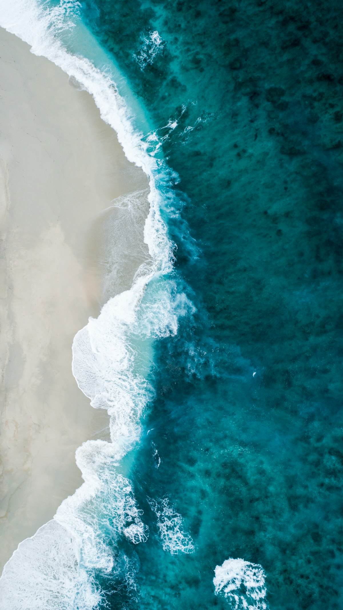
The Continental Shelf: Where Deep Water Becomes Surf
For most of its life, an ocean swell is invisible. In water deeper than half its wavelength, a swell barely affects the surface — a 20-second swell with a wavelength of about 2,000 feet only feels the bottom in water shallower than 1,000 feet. Out in the deep ocean, the entire water column from surface to a thousand feet down is moving in slow, smooth, organized circles. A surfer floating in 5,000 feet of water over an arriving 20-second swell would feel a barely perceptible rise and fall.
Everything changes when the swell reaches the continental shelf.
As water depth decreases, the wave's circular motion gets compressed. Forward speed slows down. Wavelength shortens. And — critically — height grows. A 6-foot, 18-second swell out at sea can become a 12-foot wave standing up on a shallow reef. This process is called shoaling, and it's the reason waves grow taller as they approach shore.
Two other things happen as a swell encounters shallow water:
Refraction
Waves traveling at an angle to a shoreline bend toward the shallower water. The part of the wave in deeper water moves faster than the part in shallower water, which causes the wave front to pivot. This is why swell wraps into bays and around headlands. It's also why point breaks and reef passes work: the shape of the bottom focuses (or defocuses) wave energy in predictable ways. A point break is essentially a refraction machine — a finger of land that bends incoming swell into a long, peeling wave that rolls along its length.
Diffraction
Waves also spread sideways into sheltered areas, like ripples spreading around the edge of an obstacle. This is why a corner of a bay can still get small, soft waves even when the dominant swell is being blocked by a headland. Diffraction is weaker than refraction but still meaningful, especially for long-period swells.
The interaction of shoaling, refraction, and diffraction with local bathymetry (the shape of the seafloor) is why every break has its own personality. The same swell that produces a clean three-foot wall at one beach might produce a closeout at the next beach and a perfect head-high A-frame two miles further down. Bathymetry is destiny.
The Final Step: How a Wave Breaks
A wave breaks when it can no longer support its own height. The exact threshold is governed by the wave's height-to-water-depth ratio: most waves break when the water depth is roughly 1.3 times the wave height. So a 4-foot wave will start to break in about 5 feet of water.
How a wave breaks depends mostly on the steepness of the bottom the wave is climbing.
Spilling Breaks
Gentle, gradually shoaling beaches (sandy beach breaks, mellow points) produce spilling waves. The wave's crest gradually feathers and tumbles forward as the wave climbs the slope. Spilling waves are slower, less hollow, and friendlier — they're the staple of beginner-friendly beach breaks.
Plunging Breaks
Steep, abruptly shallow bottoms (reefs, ledges, well-defined sandbars) produce plunging waves — the classic barrel. The wave hits a sudden depth change, and the crest throws forward and pitches over the trough, creating a hollow tube. Plunging breaks are more powerful, faster, and more critical to ride.
Surging Breaks
Very steep bottoms (rocky cliffs, sea walls) produce surging waves. The wave doesn't really break — it just rushes up the slope and slides back down. These aren't surfable, but they're a useful warning sign for anyone navigating reef passes or shoreline cliffs.
A single break can produce different wave types at different tides. Many reef breaks transition from spilling at high tide (more water over the reef) to plunging at low tide (less water, sharper depth change). This is why tide windows matter so much — and why the same spot can offer fundamentally different rides four hours apart.

How Knowing the Physics Makes You a Better Surfer
This isn't just trivia. Every step of a swell's journey has practical implications.
You can predict whether a forecast will deliver. When you see a storm forming on a synoptic chart, you can estimate fetch and duration and form your own opinion about swell quality. Long, sustained, distant fetches almost always produce better-quality surf than short, close, intense ones — even at the same forecast height.
You can time the peak. Because long-period forerunners arrive first, the cleanest conditions are usually within the first 24 hours of a swell's arrival, before short-period chop catches up. Showing up on day one of a long-distance swell is a high-leverage choice.
You can pick the right break for the direction. Knowing your local breaks' swell windows tells you which spots will be working and which will miss. A WSW swell that lights up one cove might leave the next bay a mile north completely flat. Mapping this out for your local zone is one of the highest-return investments you can make as a surfer.
You can understand why conditions change mid-session. When a session that started clean turns junky, it's rarely random. Either the wind has shifted, the tide has hit a critical depth threshold for the local bathymetry, or short-period energy has filled in behind the swell's leading edge. Knowing which lets you choose between waiting it out, moving spots, or going home.
You can read your wave better. Once you understand that the wave climbing toward you spent days organizing itself across thousands of miles, and that its shape is the product of a specific bottom contour bending that energy in predictable ways, you stop being a passive recipient of waves and start being an active reader of them. You start to anticipate.

The Bigger Picture
Surfing is one of the few sports where the playing field is alive — constantly moving, never the same twice, and ultimately the product of weather systems happening on the other side of the planet. The wave you're paddling for isn't just a wave — it's the tail end of a multi-day, multi-thousand-mile process that started with wind on water somewhere over the horizon.
The next time you check a forecast, look beyond the height number. Find the storm that's making the swell. Look at its position, its fetch, its speed. Notice how the period evolves through the days. The more you understand the chain of events that produced a wave, the more wave you'll see in front of you when you finally paddle out.
That's the gift of wave science. It turns a forecast into a story — and the surfer who reads the story always finds the best waves.
Want personalized coaching on reading waves and forecasts?
Neptune's AI coach can help you improve faster with personalized feedback, session tracking, and real-time conditions.